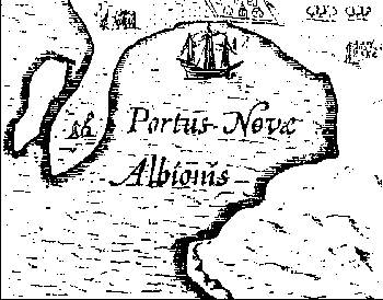
Among the hundreds of maps, manuscripts, diaries, paintings, engravings and printed works encompassing the circumnavigators, the smallest one, of not quite five square inches, has perhaps caused more ink to flow than any other - the so-called Hondius Inset, or Portus Plan. This little vignette, the upper-leftmost of five bordered insets depicting the Golden Hind on the Jodocus Hondius Broadside map of circa 1595, provides an aerial view of, according to its labeling, Portus Novae Albionis - Drake's harbor on the northwest American coast. Unfortunately, it looks a little bit like many places but not very much like any particular place.
Opinions of the importance of the Hondius Portus Plan (hereafter called the Portus Plan or "plan") have been wide ranging, from Henry Wagner's
The most important piece of evidence known to us is the plan of the "portus"to John Robertson's dismissive conjecture that
It was to illustrate such [ethnographic] details that this marginal sketch on the Hondius map was made, rather than an attempt to draw an accurate topographical chart.Most comments fall between these extremes, and the consensus remains that the plan is of major but nevertheless secondary importance. That may sound odd, but it has been an odd situation. The only contemporary graphic depiction of Drake's harbor, containing many details linking it to some of the narratives and exhibiting no contradictions with them, simply does not closely match any of the classic proposed landing sites; however, very few analysts have been willing to toss it out or ignore it. That leaves each harbor's advocate with the need to demonstrate how the plan fits his nook. The results of such efforts, along with a number of other issues surrounding the Portus Plan are discussed in my forthcoming book Francis Drake in Nova Albion - The Mystery Restored.
In the course of analysis, something previously unnoticed surfaced, which is also detailed in the book and which has a number of implications. It seems that various authorities have unwittingly used, in their publications, copies of the Portus Plan that are not true to the original. Culprits include the eminent 19th century scientist George Davidson, former University of California anthropologist Robert Heizer, writer John Robertson, former California State Historian J. Aubrey Neasham, writer Warren Hanna (his influential book Lost Harbor... contains two separate bogus plans), and last but never least the Drake Navigators Guild. Some of these inaccurate copies have appeared under the imprint of the University of California Press, the California Historical Society and the American Antiquarian Society; this is not a problem confined to amateurs or the inexperienced. It is also not very surprising, at least to this investigator who has burrowed through reams of sloppy scholarship from supposedly competent sources.
The bogus copies are good enough to lull the casual eye, but the deviations from the original are significant in several places, and in one instance completely change an important detail. In the future I may add here the comparative illustrations from my book - but for now, anyone engaged in a close analysis of the Hondius Portus Plan should be careful that they are working with a copy of the real thing.
Author's Note: Much of this material is adapted from my forthcoming book Francis Drake in Nova Albion - The Mystery Restored, in which these and neighboring thickets are explored much more deeply than on these few web pages. Thus there may be references here not fully explained, or answers missing their questions. Also lacking here is documentation, provided in the book by 782 endnotes. - Oliver Seeler